Saturday 30 March 2013

Foot-step Lego Bridge

This foot-step Lego Bridge is designed by Michael Jantzen. His proposed bridge is meant to be a new kind of public walkway. I quite like his idea to have such a kind pedestrian bridge, because it encourages us to play. It is a way to attract people to the outside and walking or running to keep health. However, too many steps can annoyed runners sometime.


Thursday 28 March 2013

Alternatives to Suburban Sprawl 2010 - Rouse Hill


PROBLEMS

• High density in the urban area

• Incomplete facilities in many suburban areas

SOLUTIONS

The Rouse Hill Town Centre in Sydney’s northwest was designed by the public development company Landcom and other private developers. The high density urban core has a significant proportion of new retail, apartment and community floor space and is planned to be the cen- tre of more medium density development around its edge. Within 12 years there will be 1800 homes, more than 3000 jobs and the Northwest Rail Link at the front door. 


Wednesday 27 March 2013

Venice (Venezia)

venice is a city in northeastern Italy sited on a group of 118 small islands separated by canals and liked by bridges.

'Venice is fish'

- City of water: 118 islands + hundreds of canals
- City of Bridges: >400 bridges that permit to cross the canals and connect all the cities.
- City of Condole: the most famous and romantic means for experiencing the city.
- City of Lights: when the sun goes down -> illuminated city


Venice is made up of 6 neighbourhoods called Sestiere.
- Cannaregio: touristy + commercial + artisan, the only 'real' shopping promenade of Venice.
- Dorsoduro: upper-class. Elegant houses.
- San Polo: hosting the only 'real' market. 'Foodie' area.
- Santa Croce: residential
- San Marco: Touristy
- Castello: largest neighbourhood. Middle-class. Venice of Venetians.
- Giudecca: blue-collor neighbourhood. 

Bridges in Venice


^ Rialto Bridge 1588-1591 by Antonio da Ponte.

It is the older bridge across the canal, and was the dividing line for the districts of San Marco and San Polo.

^ Ponte della Liberta - Liberty Bridge, 1841-1846

The Liberty Bridge is 5km long, connecting the historical center of Venice with the mainland.


Festa del Redentore - Preparations for the Festival. 

The Festa del Redentore is an event held in Venice in July where the fireworks play an important role. The engineers assemble the pontoon bridge very quickly, and by late afternoon it is ready for use.

Ponte della Costituzione ( Constitution Bridge) 2008

Designed by Santiago Calatrava. Connecting Stazione di Santa Lucia to Piazzale Roma. It is a newly designed bridge. The material used for this bridge is quite different comparing with the traditional brick, stone or wood bridge. This bridge has two glass sides


Sunday 24 March 2013

New Garden Suburbs (Sydney 1910)


PROBLEMS
• Upper middle class families moving to new suburbs
• Previous grid designs which were unsympathetic to Sydney’s unique landscape


SOLUTIONS
The suburb of Castlecrag is one of Australia’s most significant early urban and landscape de- signs by the American architect Walter Burley Griffin. There is no fences, no boundaries, and no red roofs to spoil the steep leafy hillside landscape. The roads of Castlecrag were planned to suit the topography of the area; following the natural contours of the land, reflecting Griffin’s belief that the built environment should complement the natural environment. 


Designed: Walter Burley Griffin Built: Greater Sydney Develop- ment Association (GSDA)
Year: 1921 


Friday 22 March 2013

City Observation: Railway Square

Railway Square with rising glass bus shelters and four sculptures light towers with colored steel ribbons inside which representing the four elements (Air, Water, Earth and Fire) were installed in 1999 along George Street. 


The use of glass for the Railway Square is quite unique and elegant. Australian love sunshine, glass can let sunshine go through and it can broader people’s view. Glass will not darken the area, instead, it can create some nice shadows on the ground. 


Lee Street has a 5-lane arterial, 2 lanes to the west of Sydney and 3 lanes to the inner part of Sydney. It carries with many modes of transit, from large size trucks, coaches and express buses, medium size emergency vehicles and local buses to small size personal vehicles. The closest vehicle lane to the station is bus lane.
Traffic flow is bad during the peak hours, there was a long queue waiting at the intersection, which block the bus to get in the stop. 

Lean rails offer some comfort to transit patrons, but they don’t encourage longer stays.    

Along the street, stainless steel chairs at the station for passengers who are waiting for the bus. They are protected by the sheds from bad weathers. 

Umbrellas, coffee tables, rattan chairs are nicely arranged long the glass fences. It is a great place for resting, slows down people’s pace from busy travelling. 


Monday 18 March 2013

The Green City, Sydney 2010


PROBLEMS
• Very dispersed and disparate ‘green network’ • Low levels of green space per capita in Sydney

SOLUTIONS
Two parks of very different scales exemplify recent parkland projects. First is Western Sydney parkland which is a huge linear reserve network designed to cater for residents of Western Sydney. Alternatively, Pirrama park is a small, well designed urban parkland which reconnects the city and harbour in inner city Pyrmont which was redeveloped in the 1980’s and 90’s. 


Sunday 17 March 2013

Maroubra (Anzac Pde near Wade St)

When I was waiting a bus in a small station in Maroubra, I looked around the surrounding environment...

There is a large green space in the middle of the street that separates the road to two streets with different directions. The picture above shows the vehicle lane direct to maroubra junction, the opposite one is to la prouse. Most of the green space in the middle is used for parking and there are some wooden barriers between the vehicle lane and the green space for protecting pedestrians from passing vehicles. There are some openings left among the wooden barriers for passengers to go through. No traffic lights and sidewalks nearby.


Shed is designed to protect people from bad weathers. The window shown in the picture above is not correctly designed. When I was seating there, my sight is higher than the window so I need to bend over to see if there is any bus coming. And there is no rubbish bins around! 


Path for vehicles to turn round or go across.


The road surface starts to crack. Gutter to operate drainage system along the curb.


Saturday 16 March 2013

Historic Houses Trust – The Mint


The building known as The Mint, is the Head Office of the Historic Houses Trust of New South Wales, which runs 12 public museums and historic houses, including the Hyde Park Barracks Museum next door.

The Royal Mint, Sydney, operated on this site from 1855 to 1926, processing over 1200 tons of gold from the Australian goldfields and producing over 150 million coins. The building then housed Government offices and later a museum. The surviving colonial buildings have been conserved, and new buildings seamlessly integrated with the historic structures.

I like to step on the red sand/stones under foot. Simple and nice courtyard surrounded by the brick and sandstone made houses. The design is quite different comparing with the modern glass buildings on the other side of Macquarie street.


Wednesday 13 March 2013

Early City Form - The City Shaped (Spiro Kostof)


Through synoecism, several independent villages are consolidated into a single community.


In the case of the Precolumbian city of Teotihuacan (Mexico), the administrative powers invested in the religious complex were sufficient to substitute a formal orthogonality for the pattern of village that originally occupied the site.


Service precincts grow up near palace, temple, or fortress compounds, attracted by their concentration of wealth.

Urban Land Recycled - Central Park

PROBLEMS

• Housing prices and population growth
• The largest remaining brownfield CBD site


SOLUTIONS

Central Park in Chippendale, is a major mixed use urban renewal project built on the former Carlton united brewery site. The development is centred around a public park located just off Broadway and has retained and renovated the original brewery yard. The major residential and commercial buildings are being touted as ‘sustainable’ have been designed by ‘starchitects’ such as Jean Nouvel and Richard Rogers. 


Central Park under construction now 

 
Central Park after complete


Sunday 10 March 2013

Martin Place visit

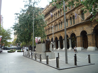
Martin Place is Sydney’s best known and most symbolic public space. It was opened in 1891 and was named in honour of Sir James Martin. Many heritage buildings surround Martin Place: the Sydney GPO, the Commonwealth Bank of Australia, Macquarie Bank…

The traffic is closed in 1971 and now Martin Place becomes a pedestrian precinct. Martin Place features the 1927 World War (ANZAC Cenotaph), water fountain, flowerbed, entertainment area, and stairs for seating.

I quick like the texture feeling of the sandstone heritage buildings. The stairs are built following with the typography of Martin Place. It is very popular in lunchtime for the workers. I also like to have a short stay seating on one of the wooden chairs under the shadow created by the surrounding trees. The busy traffic around creates a lot of noise, but it is still good to have such a lovely pedestrian path in the CBD. 


(^ Photo taken on Pitt Street, facing George Street)


(^ Photo taken in front of GPO, facing Pitt Street)


(^ Works are having a rest on the stairs)


(^ Flower beds are taking care by someone)


(^ ANZAC Cenotaph)


(^ GPO)


(^ Tourists are visiting Martin Place)

(^ Martin place shopping circle: connected with railway station and MLC centre)


(^ Texture)


(^ Wooden chairs under shadow)

Saturday 9 March 2013

'Westfield' and market in Bondi Junction (Saturday)


Bondi junction is a crowed place on Saturday. The large ‘Westfield’ shopping center attracts a lot of people. It has two blocks connected to each other. The passageway from one building to the other is like a bridge above the street. This kind of shopping center saves people’s time, providing them with a safe and comfortable shopping environment.


There is a market on Oxford Street, just beside the ‘Westfield Shopping Center’. This market is for pedestrian walk only. Private owners rent different sizes of the ground and the retail shops are arranged on two sides of a path. No barriers between the retail shops. Retail shops include flower shops, farm shops, snack shops and clothes shops, etc. Most of the things selling here are for quick buy and take away. 
I like the white canopies here, protect passengers under different weathers. And there are very harmonious with the surrounding environment.